 Geodly
North America
Mexico
Mexico lies in the southern part of North America, between the United States to the north and Guatemala and Belize to the south-east, with the Pacific Ocean on one side and the Gulf of Mexico and the Caribbean on the other. With around 130 million people, it has the largest Spanish-speaking population in the world. The country is a federal republic of 31 states plus Mexico City, the capital.
Mexico was home to some of the great civilisations of the Americas, including the Olmec, the Maya and the Aztecs. The Aztec capital, Tenochtitlan, was built on an island in Lake Texcoco, and Mexico City now stands on the same site. Spanish forces conquered the Aztec Empire in 1521. The fight for independence began on 16 September 1810, still celebrated as Independence Day, and Mexico became independent in 1821.
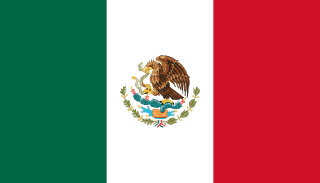
The flag of Mexico
The flag has three vertical stripes of green, white and red, with the national coat of arms in the centre of the white stripe: an eagle perched on a cactus, eating a snake.
The coat of arms comes from an Aztec legend. The god Huitzilopochtli told the Mexica people to build their city where they found an eagle on a cactus growing from a rock in a lake, and that place became Tenochtitlan. The three colours date from the independence era. Their meaning has been described in different ways over time; today green is often linked to hope, white to unity and red to the blood of national heroes.
Landscape and geography
Much of Mexico is a high central plateau framed by two mountain ranges, the Sierra Madre Occidental in the west and the Sierra Madre Oriental in the east. A belt of volcanoes crosses the country south of Mexico City, including Popocatépetl and Pico de Orizaba, which at about 5,600 metres is the highest mountain in Mexico and the highest volcano in North America. The north is largely desert, while the south has tropical rainforest.
In the south-east, the flat limestone Yucatán Peninsula has almost no rivers on the surface. Instead, water flows underground and appears in thousands of cenotes, natural sinkholes that the Maya treated as sacred. To the north-west, the long, narrow Baja California peninsula separates the Gulf of California from the Pacific.
Did you know?
- The Chicxulub crater, buried under the Yucatán Peninsula, was left by the asteroid impact linked to the extinction of the dinosaurs.
- Maize, chocolate, vanilla and chilli peppers were all first domesticated or used in Mesoamerica, the region that includes Mexico.
- Mexico City is slowly sinking because it is built on the soft bed of a former lake and draws water from underground.
- The Day of the Dead, celebrated in early November, is recognised by UNESCO as part of the world’s intangible cultural heritage.
Key facts
- Capital
- Mexico City
- Continent
- North America
- Population
- About 128 million
- Land neighbours
- 3
- Coast
- Has a coastline
- European Union
- Not a member
- NATO
- Not a member
Land neighbours
World rankings
Geo Sort asks you to place countries by rank. A lower number means a higher place in that category.
| Land Area | #14 |
|---|---|
| Coastline | #13 |
| FIFA Ranking (M) | #16 |
| Military Strength | #32 |
| Avg Annual Temperature | #55 |
| UNESCO Sites | #7 |
| Population Density | #121 |
| Highest Point | #15 |
Practise Mexico on Geodly
- Flag Drawing: The flag of Mexico is in the Easy set. Draw it from memory and compare your drawing with the real design.
- Border Clash: Draw the border between Mexico and the United States on a blank map.
- Geo Click: Find Mexico on the map, or locate its capital, Mexico City, in the capital modes.
- Geo Chain: Link countries through shared land borders. Knowing the 3 neighbours of Mexico gives you more routes.
- Geo Sort: Place Mexico in the category where its world rank is strongest.
- Terra Tac Toe: Use Mexico as an answer when its facts fit both the row and the column of a square.
Sources: Encyclopaedia Britannica: Mexico · CIA World Factbook: Mexico