 Geodly
South America
Chile
Chile is one of the most unusually shaped countries in the world. It stretches more than 4,000 kilometres along the western edge of South America, from the Peruvian border to Cape Horn, yet it is on average less than 200 kilometres wide. The Andes form its eastern border and the Pacific Ocean its western one, so a short drive can take you from the coast to mountains more than 6,000 metres high.
Chile declared independence from Spain in 1818 after a war led by figures such as Bernardo O’Higgins and José de San Martín. Most Chileans live in the central valley around the capital, Santiago, where the Mediterranean climate suits farming and wine-making. Chile is the world’s largest producer of copper, and mining in the north is one of the backbones of its economy.
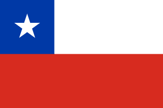
The flag of Chile
The flag has two horizontal bands, white over red, with a blue square in the upper corner by the flagpole and a white five-pointed star in the middle of the square.
The flag was adopted on 18 October 1817, during the struggle for independence. Blue is usually said to stand for the sky and the Pacific Ocean, white for the snow of the Andes, and red for the blood of those who fought for independence. The star is known as the Lone Star and is described as a guide on the path of progress and honour. The design is often compared to the flag of Texas.
Landscape and geography
Because it is so long, Chile covers a huge range of climates. The Atacama Desert in the north is one of the driest places on Earth, and its clear, dark skies make it home to several of the world’s largest astronomical observatories. The centre has warm, dry summers and wet winters. In the south, the land breaks up into fjords, islands and glaciers, with the granite towers of Torres del Paine National Park in Patagonia.
Chile lies on the Pacific Ring of Fire and has many active volcanoes. Ojos del Salado, on the border with Argentina, is the highest volcano in the world at about 6,893 metres. The country also experiences frequent earthquakes; the strongest ever recorded struck near Valdivia in 1960.
Did you know?
- Easter Island, famous for its giant moai statues, belongs to Chile even though it lies about 3,500 kilometres out in the Pacific.
- Chile claims a wedge of Antarctica that runs all the way to the South Pole.
- Chilean poets Gabriela Mistral and Pablo Neruda both won the Nobel Prize in Literature.
- Parts of the Atacama Desert have gone years without measurable rain.
Key facts
- Capital
- Santiago
- Continent
- South America
- Population
- About 20 million
- Land neighbours
- 3
- Coast
- Has a coastline
- European Union
- Not a member
- NATO
- Not a member
Land neighbours
Chile in numbers
| Population | 19,603,733 people |
|---|---|
| Land area | 743,812 km² |
| Population density | 26.4 people/km² |
| Total GDP | $335,533,000,000 |
| GDP per capita | $17,117 |
| Life expectancy | 79.5 years |
| Unemployment rate | 8.7% |
| Coastline | 6,435 km |
| Forest coverage | 24.3% |
| Human Development Index | 0.860 |
| UNESCO World Heritage sites | 7 sites |
| Airports | 481 airports |
These are the figures used in GeoDecide. They are rounded and can lag behind the latest official statistics.
Practise Chile on Geodly
- Flag Drawing: The flag of Chile is in the Easy set. Draw it from memory and compare your drawing with the real design.
- Border Clash: Draw the border between Chile and Argentina on a blank map.
- Geo Click: Find Chile on the map, or locate its capital, Santiago, in the capital modes.
- Geo Chain: Link countries through shared land borders. Knowing the 3 neighbours of Chile gives you more routes.
- GeoDecide: Compare Chile with other countries on the statistics listed above.
- Terra Tac Toe: Use Chile as an answer when its facts fit both the row and the column of a square.
Sources: Encyclopaedia Britannica: Chile · CIA World Factbook: Chile