 Geodly
North America
Canada
Canada fills most of the northern half of North America, from the Atlantic to the Pacific and north into the Arctic Ocean. It is the second-largest country in the world by total area, after Russia, yet it has only about 40 million people. Most of them live within a few hundred kilometres of the border with the United States, which is the longest international border in the world.
Indigenous peoples have lived in the land for thousands of years. French and British settlement followed from the 1500s and 1600s, and both languages remain official today. Canada became a self-governing dominion in 1867 and gradually gained full independence, a process completed when its constitution was patriated in 1982. It has ten provinces and three territories, and its capital is Ottawa, on the border between Ontario and Quebec.
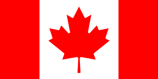
The flag of Canada
The flag has a red vertical band on each side and a white square in the middle with a red maple leaf with eleven points.
The Maple Leaf flag was adopted on 15 February 1965, a date now marked as National Flag of Canada Day. It replaced a red ensign that carried the British Union Jack. The maple leaf had long been a Canadian symbol, and the red and white are Canada’s official colours. The simple design was chosen after a long public debate, partly so that it would not favour English or French Canada.
Landscape and geography
Canada has the longest coastline of any country, including the shores of thousands of Arctic islands such as Baffin Island and Ellesmere Island. It also has more lakes than any other country, and the Great Lakes, which it shares with the United States, hold a large share of the world’s surface fresh water.
The Rocky Mountains and the Coast Mountains rise in the west. The flat prairies of Alberta, Saskatchewan and Manitoba grow much of the country’s wheat, and the rocky Canadian Shield covers a huge area around Hudson Bay. In the far north, the tundra is frozen for most of the year.
Did you know?
- Nunavut, created in 1999, is Canada’s largest and newest territory, and most of its people are Inuit.
- Canada produces the large majority of the world’s maple syrup, most of it in Quebec.
- The Bay of Fundy, between New Brunswick and Nova Scotia, has some of the highest tides in the world.
- Canada’s motto, A Mari usque ad Mare, means From Sea to Sea.
Key facts
- Capital
- Ottawa
- Continent
- North America
- Population
- About 40 million
- Land neighbours
- 1
- Coast
- Has a coastline
- European Union
- Not a member
- NATO
- Member
Land neighbours
Canada in numbers
| Population | 40,097,761 people |
|---|---|
| Land area | 9,093,507 km² |
| Population density | 4.2 people/km² |
| Total GDP | $2,140,000,000,000 |
| GDP per capita | $53,372 |
| Life expectancy | 82.6 years |
| Unemployment rate | 5.4% |
| Coastline | 202,080 km |
| Forest coverage | 38.2% |
| Human Development Index | 0.935 |
| UNESCO World Heritage sites | 22 sites |
| Airports | 1,467 airports |
These are the figures used in GeoDecide. They are rounded and can lag behind the latest official statistics.
World rankings
Geo Sort asks you to place countries by rank. A lower number means a higher place in that category.
| Land Area | #2 |
|---|---|
| Coastline | #1 |
| FIFA Ranking (M) | #50 |
| Military Strength | #27 |
| Avg Annual Temperature | #188 |
| UNESCO Sites | #17 |
| Population Density | #190 |
| Highest Point | #16 |
Practise Canada on Geodly
- Flag Drawing: The flag of Canada is in the Easy set. Draw it from memory and compare your drawing with the real design.
- Border Clash: Draw the border between Canada and the United States on a blank map.
- Geo Click: Find Canada on the map, or locate its capital, Ottawa, in the capital modes.
- Geo Chain: Link countries through shared land borders. Knowing the neighbour of Canada gives you more routes.
- GeoDecide: Compare Canada with other countries on the statistics listed above.
- Geo Sort: Place Canada in the category where its world rank is strongest.
- Terra Tac Toe: Use Canada as an answer when its facts fit both the row and the column of a square.
Sources: Encyclopaedia Britannica: Canada · CIA World Factbook: Canada